Alaska’s Deadly Skies Mapped
Alaska’s rural communities depend on a dedicated fleet of bush planes and pilots to move supplies and people across thousands of miles of roadless territory. Anyone who flies, drives, or boats know that there is risk inherent in getting around. No less than 321 people have died over the past 15 years in Alaska aviation crashes, according to a database maintained by the National Transportation Safety Board.
Click on each crash point for more information.
This map is better zooming and examining individual accidents. (Please don’t mind the web mercator projection…)
CartoDB’s quick and dirty heat map shows the obvious: Alaska’s urban core of Anchorage and the railbelt north towards the Mat-Su Valley is where many of the crashes occur. But all of bush Alaska relies on air transportation and freight for some purpose.
You also see a lot of activity in the southwest portion of the state, where the state’s third busiest airport, Bethel, serves as a hub for nearly 60 villages and in Southeast Alaska where the weather is (especially?) notoriously bad.

Flying into Tuluksak in November, 2014.
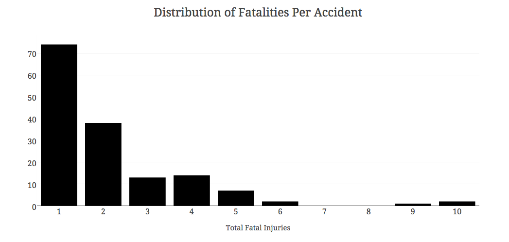
In 2015 alone, there have been 10 crashes that killed 22 people. To be honest, I had to stop and restart this project several times this fall when additional crashes changed the data set. A large majority of the crashes are limited to one or two deaths, but there are several with more than five fatalities.
2015’s 10 crashes are not out of the ordinary: 10 of the past 15 years have seen 10 or more fatal crashes. On average, just under 22 people die annually in Alaskan aviation incidents. 2009 and 2014 each had just four fatal crashes, claiming seven and five lives respectively.
2013 was the most deadly year in recent memory, when 14 fatal crashes killed 35 people and seriously injured 12. One accident can very quickly add up; 10 of the deaths came in a Rediske Air flight in Soldotna that is blamed on improper cargo storage.
I remember reporting for KYUK that fall on a Era Cessna 208 carrying six that went down near St. Mary’s in terrible weather Thanksgiving weekend. Four were killed that evening. Icing conditions may have played a role in that crash, but the NTSB has not come out with a final report.
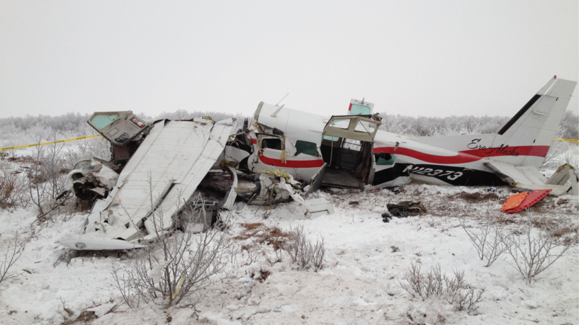
Four died when a Cessna 208 crashed near St. Mary’s. Photo courtesy of Alaska DPS.
 But it’s not during Alaska’s cold, wet, and dark winters that tragedies claim the lives of pilots and passengers. The short three months of summer account for a disproportionate amount of crashes over the past 15 years. 55% of the fatal crashes in this period happened during June, July, and August. It’s a period of intense activity: the salmon are running, there’s no shortage of daylight. People naturally get around more this time of year and spend more time in the air.
On August 9th, 2010, a plane carrying former Senator Ted Stevens and eight others aboard a went down in the Muklung Hills northeast of Dillingham. Even with a snow-free landscape, it still took hours for a rescue team to reach the hillside. Half of the plane’s occupants perished.

Former Senator Ted Stevens and four others died in while on a Bristol Bay fishing trip. Photo from Alaska DPS.
Winter is statistically a different story. February has only seen three fatal crashes in 15 years. July shows 29 crashes in the same period, killing 83 and seriously injuring six. August alone has seen more fatal crashes than the cold six-month stretch of November through April.

Data for this visualization begin in 2001, when the NTSB began consistently publishing latitude and longitude data for crashes. You can further explore the data in this spreadsheet derived from a download of NTSB data.
Notes:
This analysis looks at only crashes from 2001 to 2015 in the NTSB database that include a fatality; there are additional accidents and incidents in which the pilot and passengers survive or are uninjured. The NTSB is inconsistent in reporting several aspects of the dataset, such as make and model, purpose of flight, and FAR description. A few notes are included where latitude and longitude data had to be tweaked.
Data may be incomplete. Tools included CartoDB, Excel, Google Spreadsheets, and Plot.ly.
